University of Minnesota
http://www.umn.edu/
612-625-5000
http://www.umn.edu/
612-625-5000
Minnesota Biodiversity Atlas
Bell Museum
Dataset: MIN-Bryophytes
Search Criteria: Papua New Guinea; Central; excluding cultivated/captive occurrences
1
Page 1, records 1-3 of 3
Bell Museum bryophytes | |
 MIN:Bryophytes | 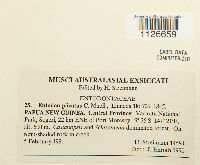 Entodon plicatus Müll. Hal. 864416[1126659]H. Streimann 145841981-02-05 Papua New Guinea, Central, Kairuku-Hiri, Varirata National Park, Sogeri, 22 km ENE of Port Moresby, -9.416667 147.35, 600m |
MIN:Bryophytes | 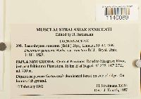 Leucobryum sanctum (Nees ex Schwägr.) Hampe 864232[1140089]Streimann, H. 152621981-02-12 Papua New Guinea, Central, Road to Musgrave River, just past Itikinumu Plantation, 16 km E of Sogeri., 700m |
MIN:Bryophytes | 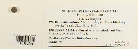 Philonotis runcinata Müll. Hal. ex Ångström 876028[1150916]Naoni, E.K. 91981-10-00 Papua New Guinea, Central, Kokoda Trail, Uberi Village (no. 2). |
1
Page 1, records 1-3 of 3
Google Map
Google Maps is a web mapping service provided by Google that features a map that users can pan (by dragging the mouse) and zoom (by using the mouse wheel). Collection points are displayed as colored markers that when clicked on, displays the full information for that collection. When multiple species are queried (separated by semi-colons), different colored markers denote each individual species.